[Edit: 7 July 2026]
Under review or in revision
Bian, Y., Li, L.*, Mu, X., Fan, W., Zhou, K., Lai, Y., Guo, Y., Xie, D., Huang, H., Yan, G., Retrieving forest background bidirectional reflectance factor by exploiting sunlit–shaded background contrast in UAV multi-angle imagery. (under revision)
Zhang, Z., Li, L.*, Yu, S., Yang, S., Song, J., Lu, H., Chen, L., Huang, H., Qi, J., Retrieving forest understory gap fraction from airborne waveform LiDAR using an energy dimidiate model. (under revision)
Gao, Y.#, Li, L.#, Shi, M., Wang, W., Yang, P., Xiao, F., Lu, H., Baret, F., Ding, Y.*, Liu, S.*, Estimation of rice leaf inclination from embedded features in millimetric-resolution UAV RGB imagery acquired at 45° viewing angle. (under revision)
Dong, M.#, Li, L.#, Zhang, M., Baret, F., Weiss, M., Ding, Y., Han, D., Wu, J., Xu, S., Liu, S.*, SNIC: A spectral normalization resistant to illumination conditions for robust estimates of GAI from UAV multispectral measurements. (under review)
Peer-reviewed articles
2026
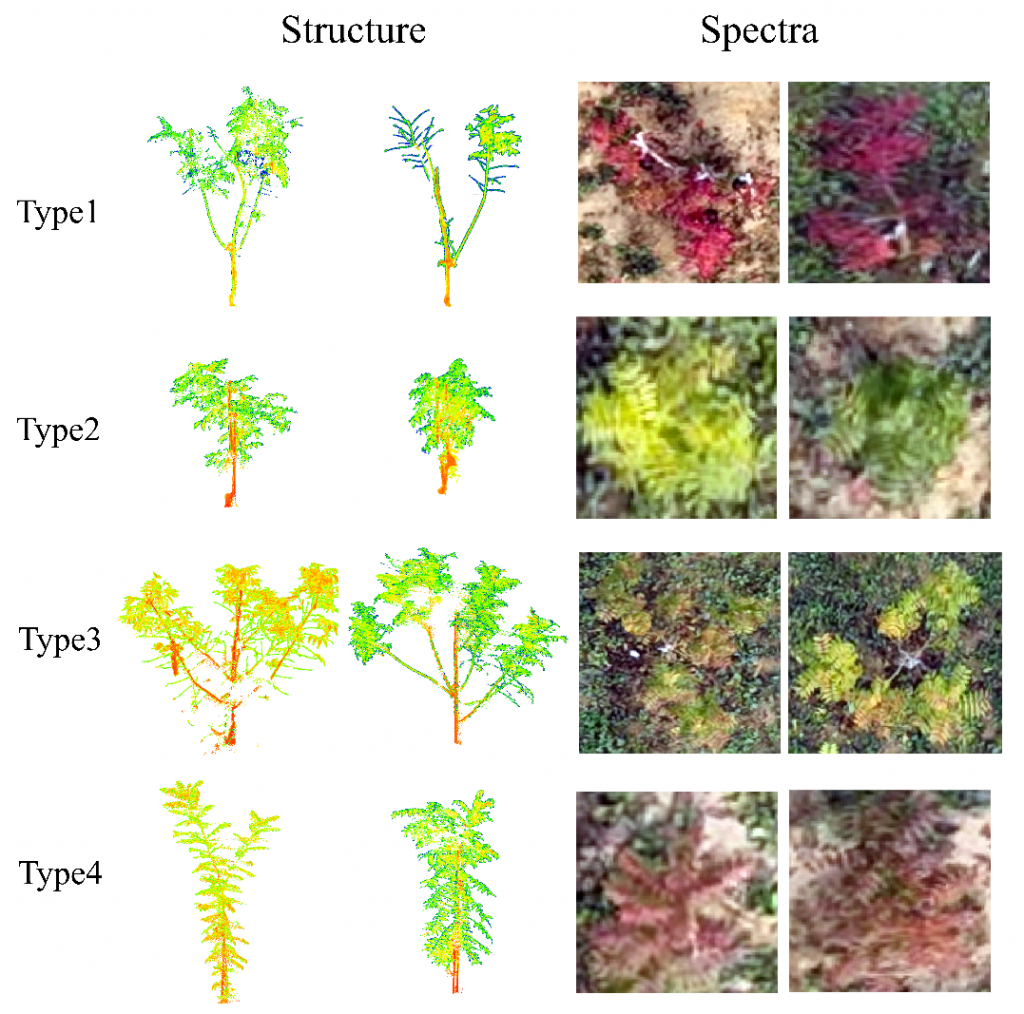
Zhang, D., Chen, L., Li, L.*, Bai, Q., Huang, H. Integrating multi-modal proximal sensing to explore structural and spectral traits of color-leaved tree seedlings for clonal selection. Smart Forestry
2025
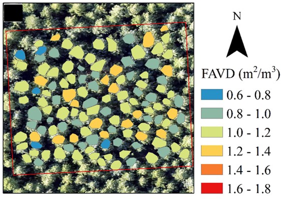
Li, L., Liu, S., Wang, Z., Zhao, X., Qi, J.*, Li, D., Guo, P., Yu, Z., Lin, S., Liu, S., Huang, H., 2025. Seeing into individual trees: tree-specific retrieval of tree-level traits using 3D radiative transfer model and spatial adjacency constraint from UAV multispectral imagery. Remote Sensing of Environment. [HTML]
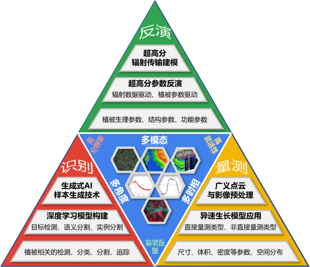
李林源, 黄华国*, 穆西晗, 阎广建, 漆建波, 严正兵, 江佳乐, 杨浩, 肖青. 2025. 低空无人机植被定量遥感:进展、挑战与展望. 遥感学报 (EN: Li, L., Huang, H.*, Mu, X., Yan, G., Qi, J., Yan, Z., Jiang, J., Yang, H., Xiao, Q. 2025. Low-altitude UAV-based quantitative remote sensing of vegetation: Advances, challenges, and prospects. National Remote Sensing Bulletin) [HTML]
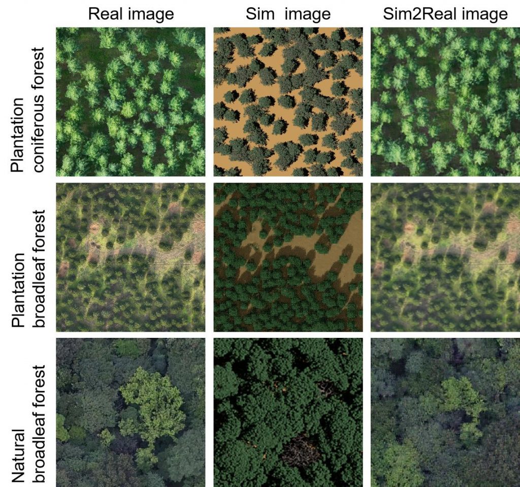
Guo, Q., Li, L.*, Yu, R., Zhang, Z., Huang, H. 2025. Simulation-to-Reality transfer learning with UAV-based imagery for forest inventory attribute prediction. Computers and Electronics in Agriculture. [HTML]
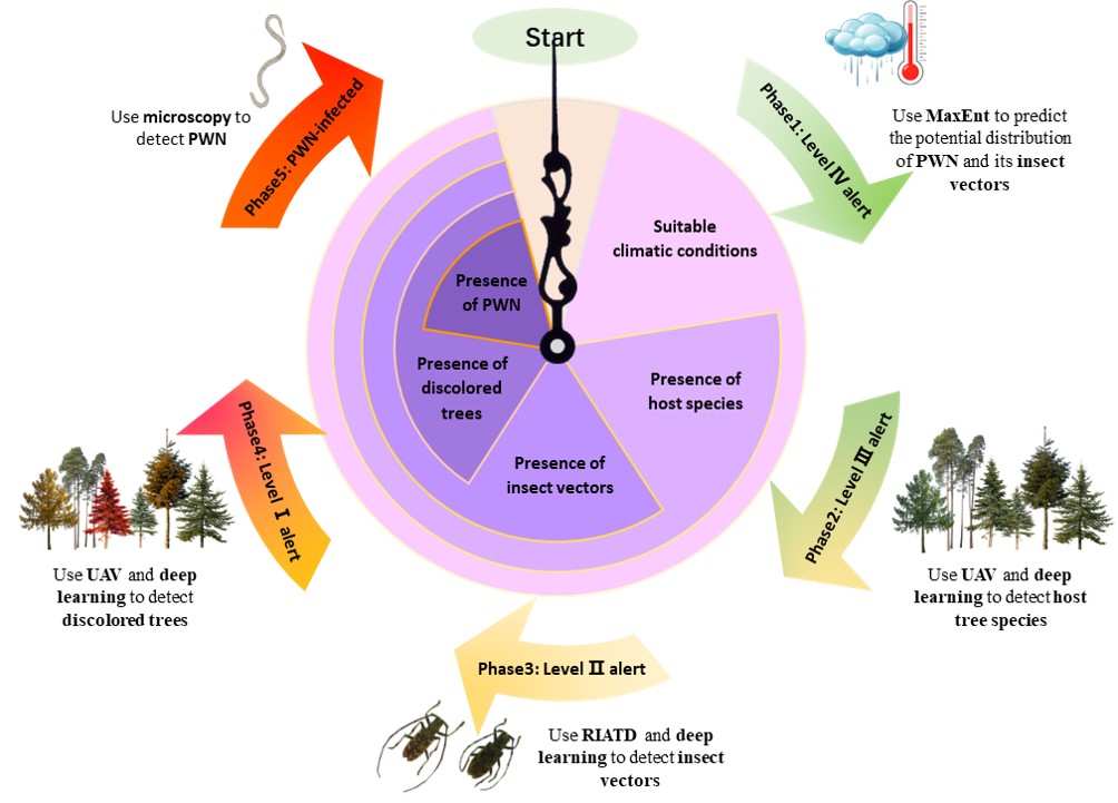
Bi, H., Xin, X., Liu, W., Li, T., Li, L.*, Zong, S.*, 2025. A four-tier warning framework for pine wilt disease: integrating species distribution models and smart sensing approaches. Pest Management Science. [HTML]
Liu, Y., Li, L.*, Liu, S., Huang, H. 2025. Angular Normalization of Airborne Hyperspectral Imagery in Forested Areas by Improved Pseudo Multi-angle Observation. IEEE Journal of Selected Topics in Applied Earth Observations and Remote Sensing [HTML]
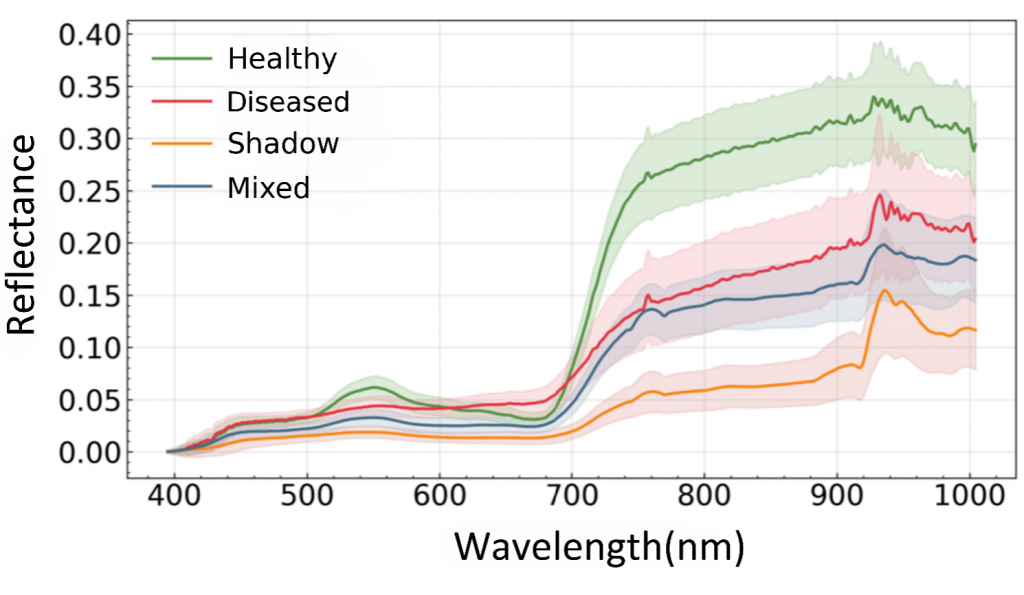
Sui, M.’, Wang, X.’, Yang, S., Li, L.*, Li, W., Nie, C., Huang, H. 2025. Diagnosis of pine wilt disease using unattended UAV hyperspectral imager: A comparison of discrete bands and continuous spectrum-based methods. Ecological Informatics. [HTML]
2024
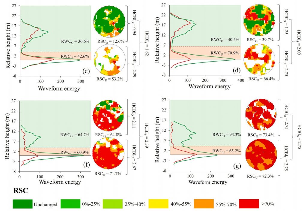
Lin, S., Li, L.*, Liu, S., Gao, G., Zhao X., Chen, L., Qi, J., Shen Q., Huang, H. 2024. Stratified burn severity assessment by integrating spaceborne spectral and waveform attributes in Great Xing’an Mountain. Remote Sensing of Environment [HTML]
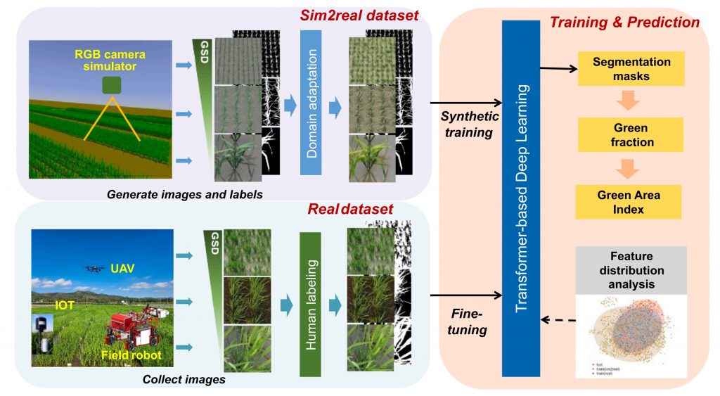
Gao, Y.’, Li, L.’, Weiss, M., Guo, W., Shi, M., Lu, H., Jiang, R., Ding, Y., Nampally, T., Rajalakshmi, P., Baret., F., Liu, S.*, 2024. Bridging Real and Simulated Data for Cross-Spatial Resolution Vegetation Segmentation with Application to Rice Crops. ISPRS J. Photogramm. Remote Sens. [HTML]
Lin, S.’, Li, L.‘, Liu, S., Yang, S., Lin, D., Zhao, X., Chen, L., Huang, H.*, 2024. Predicting post-fire forest recovery of a high-severity burned area using a process-based 3-PG model with bi-temporal Landsat imagery in Great Xing’an Mountain. Forest Ecology and Management. [HTML]
2023

Li, X., Li, L.*, Ni, W., Mu, X., Wu, X., Vaglio Laurin, G., Vangi, E., Sterenczak, K., Chirici, G., Yu, S., Huang, H., Qi, J.*, 2023. Validating GEDI tree canopy cover product across forest biomes using co-registered aerial LiDAR data. ISPRS J. Photogramm. Remote Sens. [HTML] [Corrigendum]
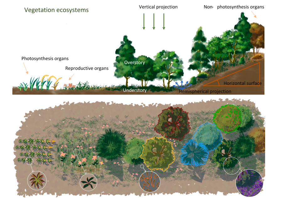
Li, L.*, Mu, X., Jiang, H., Chianucci, F., Hu, R., Song, W., Qi, J., Liu, S., Zhou, J., Chen, L., Huang, H., Yan, G., 2023. Review of ground and aerial methods for vegetation cover fraction (fCover) and related quantities estimation: definitions, advances, challenges, and future perspectives. ISPRS J. Photogramm. Remote Sens. [HTML]
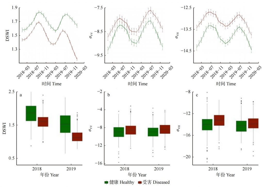
童彤,李林源*,罗涛,黄华国,联合微波与光学时间序列影像的马尾松林松材线虫病遥感识别, 北京林业大学大学学报. [HTML]
2022
Lin, S., He, Z., Huang, H., Chen, L., Li, L.*, 2022. Mixed forest-specific calibration of the 3-PGmix model parameters from site observations to predict post-fire forest regrowth. Forest Ecology and Management. [HTML]
Li, L.*, Mu, X., Chianucci F., Qi, J., Jiang, J., Zhou, J., Chen, L., Huang, H., Yan, G., Liu, S., 2022. Ultrahigh-resolution boreal forest canopy mapping: combining UAV imagery and photogrammetric point clouds in a deep-learning-based approach. International Journal of Applied Earth Observation and Geoinformation. [HTML]
2021
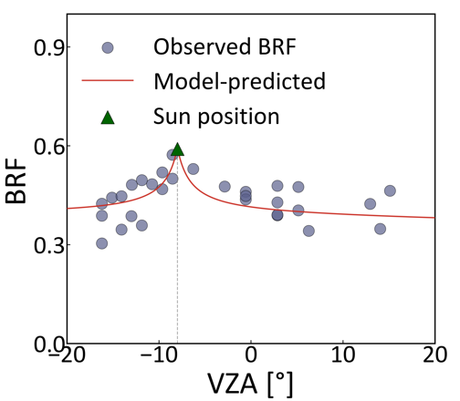
Li, L., Mu, X.*, Qi, J., Pisek, J., Roosjen, P., Yan, G., Huang, H., Liu, S., Baret, F., 2021. Characterizing soil background BRDF in open forests using UAV-based multi-angular images. ISPRS J. Photogramm. Remote Sens. [HTML]
Decai Jin, Jianbo Qi*, Huaguo Huang, Linyuan Li, 2021. Combining 3D Radiative Transfer Model and Convolutional Neural Network to Accurately Estimate Forest Canopy Cover From Very High-Resolution Satellite Images. IEEE Journal of Selected Topics in Applied Earth Observations and Remote Sensing. [HTML]
2020
Li, L., Mu, X.*, Soma, M., Wan, P., Qi, J., Hu, R., Tong, Y., Zhang, W., Yan, G., 2020. An iterative-mode scan design of terrestrial laser scanning in forests for minimising occlusion effect. IEEE Trans. Geosci. Remote Sens. [HTML]
Li, L., Chen, J., Mu*, X., Li, W., Yan, G., Xie, D., Zhang, W., 2020. Quantifying understory and overstory vegetation cover using UAV-based RGB imagery in forest plantation. Remote Sens. 2020, Vol. 12, Page 298 12, 298. [HTML]
2019
Yan, G., Li, L.*, Coy, A., Mu, X., Chen, S., Xie, D., Zhang, W., Shen, Q., Zhou, H., 2019. Improving the estimation of fractional vegetation cover from UAV RGB imagery by colour unmixing. ISPRS J. Photogramm. Remote Sens. 158, 23–34. [HTML]
Qi, J., Xie, D.*, Li, L., Zhang, W., Mu, X., Yan, G., 2019. Estimating Leaf Angle Distribution From Smartphone Photographs. IEEE Geosci. Remote Sens. Lett. 16, 1190–1194. [HTML]
Qi, J., Xie, D.*, Yin, T., Yan, G., Gastellu-Etchegorry, J.-P., Li, L., Zhang, W., Mu, X., Norford, L.K., 2019. LESS: LargE-Scale remote sensing data and image simulation framework over heterogeneous 3D scenes. Remote Sens. Environ. 221, 695–706. [HTML]
2018
Li, L., Mu, X.*, Macfarlane, C., Song, W., Chen, J., Yan, K., Yan, G., 2018. A half-Gaussian fitting method for estimating fractional vegetation cover of corn crops using unmanned aerial vehicle images. Agric. For. Meteorol. 262, 379–390. [HTML]